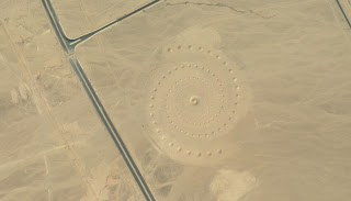
1) 27°22'49.54"N 33°37'55.93"E
3) 50° 0'38.20"N 110° 6'48.32"W
4) 19°56'56.41"S 69°38'1.38"W
5) 33°44'39.33"N 112°38'3.83"W
I thought these were pretty cool satellite images. Google Earth them (or even google maps in satellite view). They are all pretty big...the mosaic in China is the biggest I think at a mile to a side and 100 feet on the thick lines. Please share more if you have them and your thoughts on them.
Sunday, September 06, 2009
Subscribe to:
Post Comments (Atom)


3 comments:
Neat stuff.
No guesses on what 1,2 and 5 are? 3 and 4 are just cool I think though I always wonder what they were trying to say in 4.
Sarah thinks that the triangle is a landing strip and she's probably right, just done up to be cool looking. The sand circle is probably someone with a dump truck that knew the satellite was going to take a picture that day.
I'd like theories on 1,2 and 5 though.
James and I watch a lot of documentaries on these formations and more. They all discuss whether the peoples that made them were trying to signal their God(s) or aliens. Some of the documentaries are just fun but others are fascinating as scientist fight each other to prove their theories. There's a lot of proof on both sides.
-Wendy
Post a Comment